Posts

Showing posts from February, 2022

Mount Shasta

Image
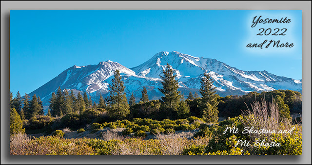
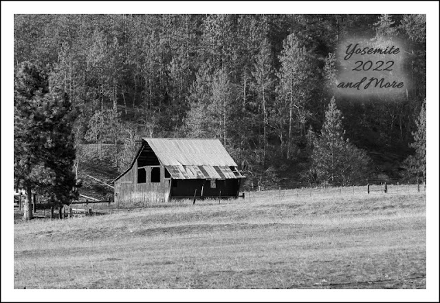
During my trip to Mt. Shasta I took some time to photograph the area near the city itself. Of course the most prominent feature of the area is the mountain. As you can see in this image there are actually two peaks. The smaller peak to the left is named Shastina, the larger is Mount Shasta itself.  As with many features in the area Shastina would be quite a attraction by itself.  Right beside Interstate 5 sits a cinder cone named Black Butte, another feature that would stand out  if not in the shadow of Mt. Shasta. The road shown is not Interstate 5. Since it's named Black Butte I thought it appropriate to post it in black and white. On the opposite side of the freeway and a bit farther off are the Eddies. Mount Eddy being the most prominent one. All part of the Trinity Mountains. I.ve always wanted to get a photo of the reflection of Mt. Shasta in  Lake Siskiyou. The farther I went to the right the more the lake was rippling from the wind. Not a perfect reflection but it will have

Clouds and Almonds

Image
 Looked outside from doing housework and noticed some enticing clouds. Got in my car and took a little trip. Low and behold the almond trees are in blossom. This is the result. Of course I took a LOT more than are posted here decisions, decisions!! Go, See, Enjoy, Stay Safe and Photograph Dave

Scott Valley

Image
Met a good friend Bill Pieruccini (isn't that a great Italian name) for lunch in the small town of Fort Jones. Bill then took me on a tour of Scott Valley. A couple these were taken before and after the tour. I used mostly black and white because I thought it best reflected the ambiance of the trip. I spotted these horses just enjoying the great weather An old Pole Barn I was treated to what is a rare site for me. A newborn calf trying to stand.  Momma continued to clean the calf and encourage it to stand.  Of course when it did manage it for a moment I was reviewing my previous shots.   Scott Valley was subjected to dredge mining for gold, which like many rivers and creeks in California left some major scars. The Callahan Red Bridge was constructed in 1908 If it was constructed today it would be concrete with no character. They don't build them like they used to. I took the 'back' way out of the Valley and came across this old house. Go, See, Enjoy, Stay Safe and Photo

Manzanar Japanese Relocation Camp

Image
 I recently visited the Manzanar Japanese Relocation Camp on the eastern side of the Sierra Nevada in Owens Valley. While I knew a little bit about it I have to say it was an eye opening experience. The wind blowing off of the mountains added to what life must have been like.  Imagine going to your new home and seeing this. Eight guard towers and five line barbed wire. I'll bet it felt more like this. There were 11,700 people detained here from 3/21/1942 (just 3 months after Pearl Harbor) in 36 Blocks with 14 Barracks each. The buildings had tar paper for siding with little regard for personal space or ethnic subtleties.  The people where allowed only to take what they could carry.  Many lost their homes, farms, wealth and health Don't forget these were individuals Their lifestyle, food and language were different than those who  planned and incarcerated them. Communal dining and barracks were the standard. Later if you had a family of four or more you were allowed more privacy

Death Valley

Image
  If you think Death Valley is a featureless landscape you'd be sadly mistaken.  This was my second trip and was awed just like the first time. I went to some places I missed and returned to others. (see my previous post from some sand dunes) To get to the valley you get to go up and over. Then you start to see some real interesting formations And different layers Lots of examples of what formed the various features One of the 'must sees' is the Devil's Golf Course.  An area formed by various salts deposited by rains into the valley, it's a huge area A closer look gives you some idea of what the formations look like Some large Some small and very interesting Next up is the lowest point in the United States, Badwater Basin, so named after a  prospectors mules wouldn't drink from the water. The little white sign on the hill  is sea level, 282 feet above the basin. The salts in the basin are mostly NaCl, yup, table salt. This is from the Artists Palette section. I